|
|
|||||||||||||||||
| Point ID: 487 | Downloads | Plots | Site Data | Code: 05DF006 |
|
|
|||||||||||||||||
| Download | |
|---|---|
| Site Descriptor Information | Site Time Series Data |
| Link to all available data | |
| View: | Time Series | All |
| Units: | mm |
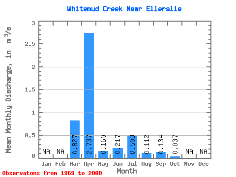
| Statistic | Jan | Feb | Mar | Apr | May | Jun | Jul | Aug | Sep | Oct | Nov | Dec | Annual |
|---|---|---|---|---|---|---|---|---|---|---|---|---|---|
| Mean | 0.83 | 2.74 | 0.16 | 0.22 | 0.50 | 0.11 | 0.13 | 0.04 | |||||
| Standard Deviation | 1.00 | 3.61 | 0.18 | 0.35 | 0.85 | 0.24 | 0.39 | 0.07 | |||||
| Min | 0.00 | 0.01 | 0.00 | 0.00 | 0.00 | 0.00 | 0.00 | 0.00 | |||||
| Max | 3.63 | 18.00 | 0.81 | 1.30 | 3.81 | 1.02 | 1.91 | 0.31 | |||||
| Coefficient of Variation | 1.21 | 1.32 | 1.10 | 1.60 | 1.69 | 2.15 | 2.93 | 2.04 |
 Return to R-Arctic Net Home Page