|
|
|||||||||||||||||
| Point ID: 482 | Downloads | Plots | Site Data | Code: 05DE009 |
|
|
|||||||||||||||||
| Download | |
|---|---|
| Site Descriptor Information | Site Time Series Data |
| Link to all available data | |
| View: | Time Series | All |
| Units: | mm |
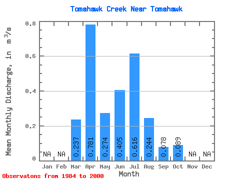
| Statistic | Jan | Feb | Mar | Apr | May | Jun | Jul | Aug | Sep | Oct | Nov | Dec | Annual |
|---|---|---|---|---|---|---|---|---|---|---|---|---|---|
| Mean | 0.24 | 0.78 | 0.27 | 0.41 | 0.62 | 0.24 | 0.08 | 0.09 | |||||
| Standard Deviation | 0.17 | 0.86 | 0.31 | 0.54 | 0.79 | 0.44 | 0.06 | 0.08 | |||||
| Min | 0.04 | 0.04 | 0.01 | 0.04 | 0.03 | 0.00 | 0.01 | 0.01 | |||||
| Max | 0.61 | 2.64 | 1.19 | 1.69 | 2.47 | 1.44 | 0.22 | 0.27 | |||||
| Coefficient of Variation | 0.74 | 1.10 | 1.12 | 1.34 | 1.28 | 1.82 | 0.79 | 0.89 |
 Return to R-Arctic Net Home Page