|
|
|||||||||||||||||
| Point ID: 479 | Downloads | Plots | Site Data | Code: 05DE006 |
|
|
|||||||||||||||||
| Download | |
|---|---|
| Site Descriptor Information | Site Time Series Data |
| Link to all available data | |
| View: | Time Series | All |
| Units: | mm |
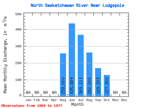
| Statistic | Jan | Feb | Mar | Apr | May | Jun | Jul | Aug | Sep | Oct | Nov | Dec | Annual |
|---|---|---|---|---|---|---|---|---|---|---|---|---|---|
| Mean | 258.00 | 435.89 | 369.11 | 262.00 | 169.33 | 127.30 | |||||||
| Standard Deviation | 78.05 | 218.42 | 195.09 | 100.77 | 46.52 | 42.82 | |||||||
| Min | 182.00 | 188.00 | 169.00 | 128.00 | 109.00 | 67.20 | |||||||
| Max | 361.00 | 874.00 | 705.00 | 451.00 | 228.00 | 185.00 | |||||||
| Coefficient of Variation | 0.30 | 0.50 | 0.53 | 0.39 | 0.28 | 0.34 |
 Return to R-Arctic Net Home Page