|
|
|||||||||||||||||
| Point ID: 477 | Downloads | Plots | Site Data | Code: 05DE001 |
|
|
|||||||||||||||||
| Download | |
|---|---|
| Site Descriptor Information | Site Time Series Data |
| Link to all available data | |
| View: | Time Series | All |
| Units: | mm |
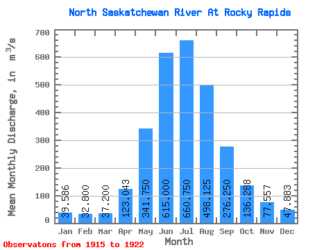
| Statistic | Jan | Feb | Mar | Apr | May | Jun | Jul | Aug | Sep | Oct | Nov | Dec | Annual |
|---|---|---|---|---|---|---|---|---|---|---|---|---|---|
| Mean | 39.59 | 32.80 | 37.20 | 123.04 | 341.75 | 615.00 | 660.75 | 498.12 | 276.25 | 136.29 | 77.56 | 47.88 | 256.45 |
| Standard Deviation | 12.10 | 4.70 | 10.23 | 39.25 | 201.90 | 277.06 | 287.65 | 108.57 | 91.16 | 39.49 | 30.08 | 16.47 | 64.46 |
| Min | 28.00 | 24.80 | 23.90 | 53.30 | 174.00 | 318.00 | 402.00 | 341.00 | 135.00 | 96.30 | 49.20 | 27.40 | 169.30 |
| Max | 58.20 | 39.20 | 52.10 | 177.00 | 691.00 | 1230.00 | 1260.00 | 695.00 | 448.00 | 207.00 | 127.00 | 76.90 | 356.74 |
| Coefficient of Variation | 0.31 | 0.14 | 0.28 | 0.32 | 0.59 | 0.45 | 0.43 | 0.22 | 0.33 | 0.29 | 0.39 | 0.34 | 0.25 |
 Return to R-Arctic Net Home Page