|
|
|||||||||||||||||
| Point ID: 463 | Downloads | Plots | Site Data | Code: 05DC006 |
|
|
|||||||||||||||||
| Download | |
|---|---|
| Site Descriptor Information | Site Time Series Data |
| Link to all available data | |
| View: | Time Series | All |
| Units: | mm |
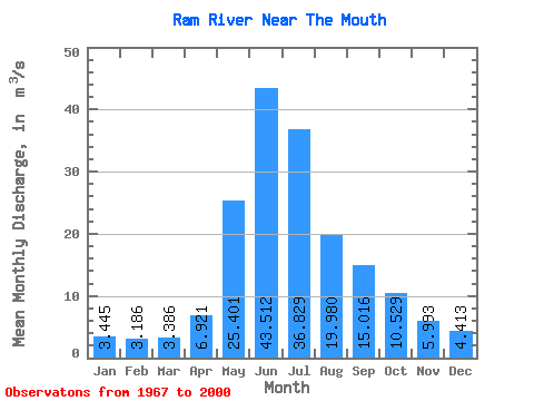
| Statistic | Jan | Feb | Mar | Apr | May | Jun | Jul | Aug | Sep | Oct | Nov | Dec | Annual |
|---|---|---|---|---|---|---|---|---|---|---|---|---|---|
| Mean | 3.44 | 3.19 | 3.39 | 6.92 | 25.40 | 43.51 | 36.83 | 19.98 | 15.02 | 10.53 | 5.99 | 4.41 | 14.87 |
| Standard Deviation | 0.70 | 0.60 | 0.95 | 2.38 | 12.54 | 22.77 | 22.25 | 8.66 | 7.67 | 4.22 | 1.75 | 0.95 | 4.13 |
| Min | 2.66 | 2.18 | 2.09 | 2.77 | 8.25 | 11.50 | 13.70 | 8.65 | 6.71 | 5.42 | 3.61 | 3.00 | 9.74 |
| Max | 5.24 | 4.40 | 5.83 | 12.50 | 58.70 | 96.00 | 107.00 | 43.90 | 36.00 | 22.30 | 12.10 | 6.54 | 21.75 |
| Coefficient of Variation | 0.20 | 0.19 | 0.28 | 0.34 | 0.49 | 0.52 | 0.60 | 0.43 | 0.51 | 0.40 | 0.29 | 0.22 | 0.28 |
 Return to R-Arctic Net Home Page