|
|
|||||||||||||||||
| Point ID: 454 | Downloads | Plots | Site Data | Code: 05DB004 |
|
|
|||||||||||||||||
| Download | |
|---|---|
| Site Descriptor Information | Site Time Series Data |
| Link to all available data | |
| View: | Time Series | All |
| Units: | mm |
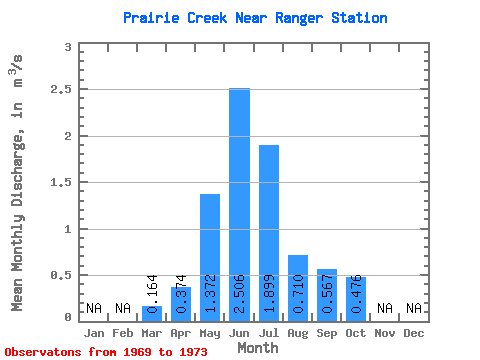
| Statistic | Jan | Feb | Mar | Apr | May | Jun | Jul | Aug | Sep | Oct | Nov | Dec | Annual |
|---|---|---|---|---|---|---|---|---|---|---|---|---|---|
| Mean | 0.16 | 0.37 | 1.37 | 2.51 | 1.90 | 0.71 | 0.57 | 0.48 | |||||
| Standard Deviation | 0.04 | 0.08 | 0.53 | 1.46 | 1.39 | 0.30 | 0.24 | 0.21 | |||||
| Min | 0.11 | 0.27 | 1.03 | 1.26 | 0.95 | 0.40 | 0.34 | 0.28 | |||||
| Max | 0.20 | 0.43 | 2.31 | 4.90 | 4.26 | 1.12 | 0.94 | 0.81 | |||||
| Coefficient of Variation | 0.23 | 0.20 | 0.39 | 0.58 | 0.73 | 0.42 | 0.42 | 0.45 |
 Return to R-Arctic Net Home Page