|
|
|||||||||||||||||
| Point ID: 4431 | Downloads | Plots | Site Data | Code: 05QB006 |
|
|
|||||||||||||||||
| Download | |
|---|---|
| Site Descriptor Information | Site Time Series Data |
| Link to all available data | |
| View: | Time Series | All |
| Units: | mm |
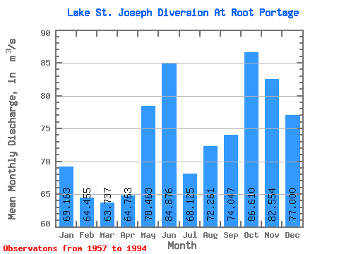
| Statistic | Jan | Feb | Mar | Apr | May | Jun | Jul | Aug | Sep | Oct | Nov | Dec | Annual |
|---|---|---|---|---|---|---|---|---|---|---|---|---|---|
| Mean | 69.16 | 64.45 | 63.74 | 64.76 | 78.46 | 84.88 | 68.12 | 72.26 | 74.05 | 86.61 | 82.55 | 77.00 | 73.84 |
| Standard Deviation | 39.88 | 38.07 | 28.33 | 25.66 | 32.81 | 42.51 | 51.13 | 46.03 | 53.80 | 51.70 | 52.69 | 48.04 | 21.28 |
| Min | 0.00 | 0.00 | 0.00 | 0.00 | 0.00 | 0.00 | 0.00 | 0.00 | 0.00 | 0.00 | 0.00 | 0.00 | 21.19 |
| Max | 137.00 | 134.00 | 113.00 | 130.00 | 146.00 | 179.00 | 181.00 | 176.00 | 189.00 | 170.00 | 170.00 | 157.00 | 109.49 |
| Coefficient of Variation | 0.58 | 0.59 | 0.45 | 0.40 | 0.42 | 0.50 | 0.75 | 0.64 | 0.73 | 0.60 | 0.64 | 0.62 | 0.29 |
 Return to R-Arctic Net Home Page