|
|
|||||||||||||||||
| Point ID: 4413 | Downloads | Plots | Site Data | Code: 05PD026 |
|
|
|||||||||||||||||
| Download | |
|---|---|
| Site Descriptor Information | Site Time Series Data |
| Link to all available data | |
| View: | Time Series | All |
| Units: | mm |
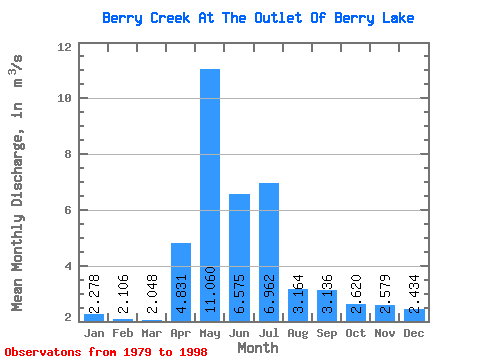
| Statistic | Jan | Feb | Mar | Apr | May | Jun | Jul | Aug | Sep | Oct | Nov | Dec | Annual |
|---|---|---|---|---|---|---|---|---|---|---|---|---|---|
| Mean | 2.28 | 2.11 | 2.05 | 4.83 | 11.06 | 6.58 | 6.96 | 3.16 | 3.14 | 2.62 | 2.58 | 2.43 | 4.13 |
| Standard Deviation | 1.63 | 1.22 | 1.10 | 3.31 | 9.11 | 3.72 | 4.63 | 3.23 | 4.43 | 2.33 | 2.62 | 2.59 | 2.34 |
| Min | 0.39 | 0.39 | 0.46 | 0.73 | 0.74 | 0.73 | 0.73 | 0.42 | 0.06 | 0.05 | 0.02 | 0.01 | 0.68 |
| Max | 6.13 | 4.28 | 3.92 | 11.30 | 27.20 | 12.00 | 19.60 | 11.70 | 18.00 | 6.96 | 9.97 | 10.40 | 9.43 |
| Coefficient of Variation | 0.72 | 0.58 | 0.54 | 0.69 | 0.82 | 0.57 | 0.67 | 1.02 | 1.41 | 0.89 | 1.02 | 1.07 | 0.57 |
 Return to R-Arctic Net Home Page