|
|
|||||||||||||||||
| Point ID: 4387 | Downloads | Plots | Site Data | Code: 05PB001 |
|
|
|||||||||||||||||
| Download | |
|---|---|
| Site Descriptor Information | Site Time Series Data |
| Link to all available data | |
| View: | Time Series | All |
| Units: | mm |
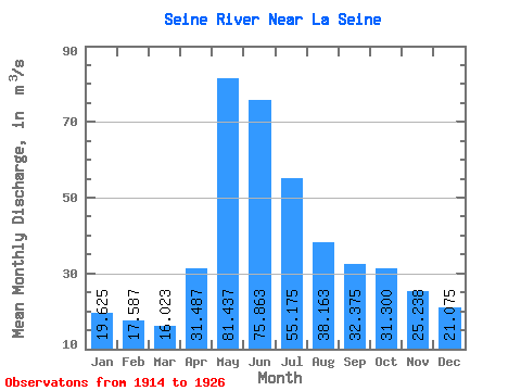
| Statistic | Jan | Feb | Mar | Apr | May | Jun | Jul | Aug | Sep | Oct | Nov | Dec | Annual |
|---|---|---|---|---|---|---|---|---|---|---|---|---|---|
| Mean | 19.62 | 17.59 | 16.02 | 31.49 | 81.44 | 75.86 | 55.17 | 38.16 | 32.38 | 31.30 | 25.24 | 21.07 | 34.48 |
| Standard Deviation | 4.12 | 4.73 | 4.76 | 14.57 | 53.29 | 40.66 | 21.11 | 13.06 | 11.07 | 10.81 | 8.82 | 5.71 | 5.58 |
| Min | 12.90 | 11.00 | 8.28 | 13.20 | 32.30 | 45.70 | 32.10 | 23.20 | 19.00 | 17.70 | 11.30 | 10.30 | 28.22 |
| Max | 25.90 | 24.20 | 22.60 | 51.30 | 197.00 | 169.00 | 89.60 | 62.70 | 51.70 | 47.80 | 34.70 | 27.00 | 42.12 |
| Coefficient of Variation | 0.21 | 0.27 | 0.30 | 0.46 | 0.65 | 0.54 | 0.38 | 0.34 | 0.34 | 0.34 | 0.35 | 0.27 | 0.16 |
 Return to R-Arctic Net Home Page