|
|
|||||||||||||||||
| Point ID: 437 | Downloads | Plots | Site Data | Code: 05CK004 |
|
|
|||||||||||||||||
| Download | |
|---|---|
| Site Descriptor Information | Site Time Series Data |
| Link to all available data | |
| View: | Time Series | All |
| Units: | mm |
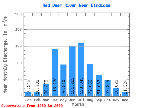
| Statistic | Jan | Feb | Mar | Apr | May | Jun | Jul | Aug | Sep | Oct | Nov | Dec | Annual |
|---|---|---|---|---|---|---|---|---|---|---|---|---|---|
| Mean | 10.24 | 10.74 | 30.38 | 113.13 | 76.51 | 121.22 | 128.34 | 77.06 | 51.07 | 39.25 | 20.03 | 11.32 | 57.50 |
| Standard Deviation | 4.77 | 4.88 | 24.00 | 85.17 | 42.25 | 67.45 | 80.80 | 29.74 | 17.77 | 17.88 | 6.76 | 5.17 | 19.00 |
| Min | 2.95 | 3.63 | 6.53 | 31.10 | 22.10 | 40.90 | 25.90 | 40.30 | 27.80 | 20.90 | 11.80 | 4.52 | 29.25 |
| Max | 18.80 | 22.00 | 122.00 | 362.00 | 248.00 | 372.00 | 362.00 | 209.00 | 122.00 | 125.00 | 42.60 | 23.90 | 118.19 |
| Coefficient of Variation | 0.47 | 0.46 | 0.79 | 0.75 | 0.55 | 0.56 | 0.63 | 0.39 | 0.35 | 0.46 | 0.34 | 0.46 | 0.33 |
 Return to R-Arctic Net Home Page