|
|
|||||||||||||||||
| Point ID: 4357 | Downloads | Plots | Site Data | Code: 04JG001 |
|
|
|||||||||||||||||
| Download | |
|---|---|
| Site Descriptor Information | Site Time Series Data |
| Link to all available data | |
| View: | Time Series | All |
| Units: | mm |
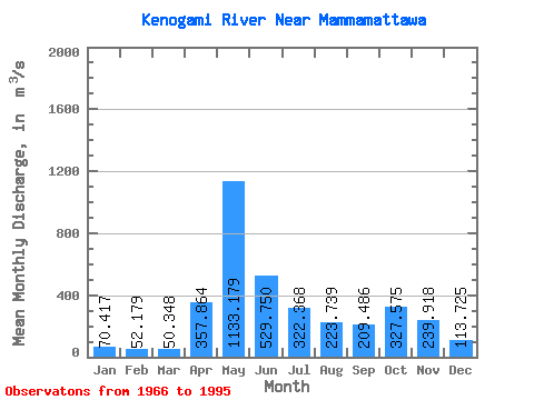
| Statistic | Jan | Feb | Mar | Apr | May | Jun | Jul | Aug | Sep | Oct | Nov | Dec | Annual |
|---|---|---|---|---|---|---|---|---|---|---|---|---|---|
| Mean | 70.42 | 52.18 | 50.35 | 357.86 | 1133.18 | 529.75 | 322.37 | 223.74 | 209.49 | 327.57 | 239.92 | 113.72 | 301.44 |
| Standard Deviation | 23.09 | 13.20 | 13.78 | 253.81 | 375.78 | 187.77 | 171.04 | 178.97 | 158.81 | 162.04 | 95.34 | 38.34 | 62.03 |
| Min | 31.00 | 29.90 | 29.00 | 55.00 | 299.00 | 235.00 | 62.30 | 36.20 | 30.30 | 47.50 | 51.20 | 35.70 | 201.42 |
| Max | 145.00 | 82.70 | 86.00 | 953.00 | 2170.00 | 1030.00 | 719.00 | 839.00 | 738.00 | 667.00 | 392.00 | 183.00 | 457.02 |
| Coefficient of Variation | 0.33 | 0.25 | 0.27 | 0.71 | 0.33 | 0.35 | 0.53 | 0.80 | 0.76 | 0.49 | 0.40 | 0.34 | 0.21 |
 Return to R-Arctic Net Home Page