|
|
|||||||||||||||||
| Point ID: 4345 | Downloads | Plots | Site Data | Code: 04GD002 |
|
|
|||||||||||||||||
| Download | |
|---|---|
| Site Descriptor Information | Site Time Series Data |
| Link to all available data | |
| View: | Time Series | All |
| Units: | mm |
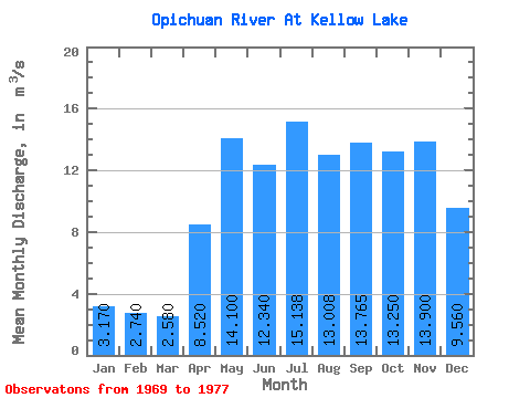
| Statistic | Jan | Feb | Mar | Apr | May | Jun | Jul | Aug | Sep | Oct | Nov | Dec | Annual |
|---|---|---|---|---|---|---|---|---|---|---|---|---|---|
| Mean | 3.17 | 2.74 | 2.58 | 8.52 | 14.10 | 12.34 | 15.14 | 13.01 | 13.77 | 13.25 | 13.90 | 9.56 | |
| Standard Deviation | 4.73 | 5.91 | 5.28 | 6.20 | 3.46 | 3.96 | |||||||
| Min | 3.17 | 2.74 | 2.58 | 8.52 | 14.10 | 9.42 | 7.65 | 7.44 | 6.49 | 10.80 | 11.10 | 9.56 | |
| Max | 3.17 | 2.74 | 2.58 | 8.52 | 14.10 | 17.80 | 22.00 | 21.70 | 21.40 | 15.70 | 16.70 | 9.56 | |
| Coefficient of Variation | 0.38 | 0.39 | 0.41 | 0.45 | 0.26 | 0.28 |
 Return to R-Arctic Net Home Page