|
|
|||||||||||||||||
| Point ID: 433 | Downloads | Plots | Site Data | Code: 05CJ012 |
|
|
|||||||||||||||||
| Download | |
|---|---|
| Site Descriptor Information | Site Time Series Data |
| Link to all available data | |
| View: | Time Series | All |
| Units: | mm |
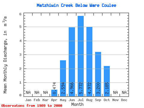
| Statistic | Jan | Feb | Mar | Apr | May | Jun | Jul | Aug | Sep | Oct | Nov | Dec | Annual |
|---|---|---|---|---|---|---|---|---|---|---|---|---|---|
| Mean | 0.47 | 2.59 | 4.97 | 5.77 | 4.97 | 3.20 | 2.19 | ||||||
| Standard Deviation | 0.14 | 1.03 | 1.37 | 1.43 | 1.19 | 1.07 | 0.63 | ||||||
| Min | 0.38 | 1.18 | 2.49 | 3.13 | 3.15 | 1.74 | 1.15 | ||||||
| Max | 0.57 | 4.69 | 7.20 | 7.70 | 6.76 | 5.24 | 2.91 | ||||||
| Coefficient of Variation | 0.29 | 0.40 | 0.28 | 0.25 | 0.24 | 0.34 | 0.29 |
 Return to R-Arctic Net Home Page