|
|
|||||||||||||||||
| Point ID: 427 | Downloads | Plots | Site Data | Code: 05CJ006 |
|
|
|||||||||||||||||
| Download | |
|---|---|
| Site Descriptor Information | Site Time Series Data |
| Link to all available data | |
| View: | Time Series | All |
| Units: | mm |
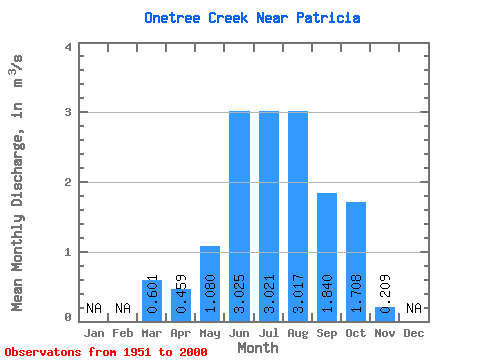
| Statistic | Jan | Feb | Mar | Apr | May | Jun | Jul | Aug | Sep | Oct | Nov | Dec | Annual |
|---|---|---|---|---|---|---|---|---|---|---|---|---|---|
| Mean | 0.60 | 0.46 | 1.08 | 3.02 | 3.02 | 3.02 | 1.84 | 1.71 | 0.21 | ||||
| Standard Deviation | 0.62 | 0.48 | 0.74 | 1.52 | 0.88 | 0.72 | 0.63 | 0.49 | 0.11 | ||||
| Min | 0.05 | 0.07 | 0.15 | 1.53 | 1.82 | 1.85 | 0.81 | 0.74 | 0.08 | ||||
| Max | 3.06 | 2.38 | 3.99 | 11.90 | 7.35 | 5.70 | 2.97 | 2.83 | 0.34 | ||||
| Coefficient of Variation | 1.03 | 1.06 | 0.69 | 0.50 | 0.29 | 0.24 | 0.34 | 0.28 | 0.51 |
 Return to R-Arctic Net Home Page