|
|
|||||||||||||||||
| Point ID: 424 | Downloads | Plots | Site Data | Code: 05CJ003 |
|
|
|||||||||||||||||
| Download | |
|---|---|
| Site Descriptor Information | Site Time Series Data |
| Link to all available data | |
| View: | Time Series | All |
| Units: | mm |
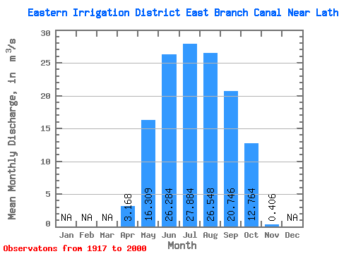
| Statistic | Jan | Feb | Mar | Apr | May | Jun | Jul | Aug | Sep | Oct | Nov | Dec | Annual |
|---|---|---|---|---|---|---|---|---|---|---|---|---|---|
| Mean | 3.17 | 16.31 | 26.28 | 27.88 | 26.55 | 20.75 | 12.76 | 0.41 | |||||
| Standard Deviation | 5.32 | 10.35 | 11.03 | 9.43 | 8.00 | 9.08 | 8.43 | 1.78 | |||||
| Min | 0.00 | 1.03 | 1.63 | 3.80 | 7.24 | 0.87 | 0.00 | 0.00 | |||||
| Max | 27.50 | 45.20 | 56.90 | 53.70 | 41.40 | 38.50 | 35.70 | 13.80 | |||||
| Coefficient of Variation | 1.68 | 0.64 | 0.42 | 0.34 | 0.30 | 0.44 | 0.66 | 4.38 |
 Return to R-Arctic Net Home Page