|
|
|||||||||||||||||
| Point ID: 411 | Downloads | Plots | Site Data | Code: 05CH001 |
|
|
|||||||||||||||||
| Download | |
|---|---|
| Site Descriptor Information | Site Time Series Data |
| Link to all available data | |
| View: | Time Series | All |
| Units: | mm |
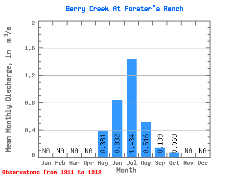
| Statistic | Jan | Feb | Mar | Apr | May | Jun | Jul | Aug | Sep | Oct | Nov | Dec | Annual |
|---|---|---|---|---|---|---|---|---|---|---|---|---|---|
| Mean | 0.38 | 0.83 | 1.43 | 0.52 | 0.14 | 0.07 | |||||||
| Standard Deviation | 0.79 | 0.25 | 0.00 | ||||||||||
| Min | 0.38 | 0.83 | 0.88 | 0.34 | 0.14 | 0.07 | |||||||
| Max | 0.38 | 0.83 | 1.99 | 0.69 | 0.14 | 0.07 | |||||||
| Coefficient of Variation | 0.55 | 0.49 | 0.03 |
 Return to R-Arctic Net Home Page