|
|
|||||||||||||||||
| Point ID: 4 | Downloads | Plots | Site Data | Code: 05AA004 |
|
|
|||||||||||||||||
| Download | |
|---|---|
| Site Descriptor Information | Site Time Series Data |
| Link to all available data | |
| View: | Time Series | All |
| Units: | mm |
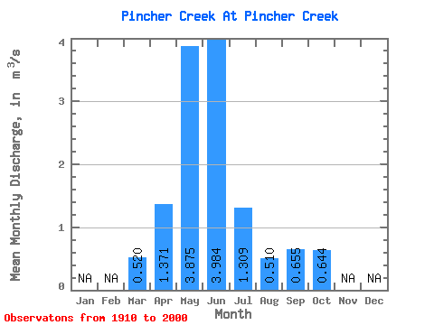
| Statistic | Jan | Feb | Mar | Apr | May | Jun | Jul | Aug | Sep | Oct | Nov | Dec | Annual |
|---|---|---|---|---|---|---|---|---|---|---|---|---|---|
| Mean | 0.52 | 1.37 | 3.88 | 3.98 | 1.31 | 0.51 | 0.66 | 0.64 | |||||
| Standard Deviation | 0.46 | 0.80 | 2.75 | 3.26 | 1.24 | 0.57 | 1.27 | 0.69 | |||||
| Min | 0.07 | 0.19 | 0.50 | 0.33 | 0.04 | 0.03 | 0.01 | 0.03 | |||||
| Max | 1.81 | 3.73 | 12.00 | 15.70 | 5.54 | 2.67 | 8.72 | 2.78 | |||||
| Coefficient of Variation | 0.89 | 0.58 | 0.71 | 0.82 | 0.95 | 1.12 | 1.94 | 1.08 |
 Return to R-Arctic Net Home Page