|
|
|||||||||||||||||
| Point ID: 388 | Downloads | Plots | Site Data | Code: 05CE003 |
|
|
|||||||||||||||||
| Download | |
|---|---|
| Site Descriptor Information | Site Time Series Data |
| Link to all available data | |
| View: | Time Series | All |
| Units: | mm |
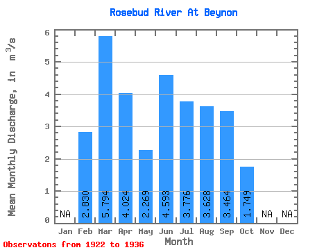
| Statistic | Jan | Feb | Mar | Apr | May | Jun | Jul | Aug | Sep | Oct | Nov | Dec | Annual |
|---|---|---|---|---|---|---|---|---|---|---|---|---|---|
| Mean | 2.83 | 5.79 | 4.02 | 2.27 | 4.59 | 3.78 | 3.63 | 3.46 | 1.75 | ||||
| Standard Deviation | 5.89 | 5.01 | 0.53 | 2.45 | 1.78 | 1.79 | 1.32 | 1.21 | |||||
| Min | 2.83 | 0.22 | 0.55 | 1.37 | 1.58 | 2.37 | 1.88 | 1.90 | 0.59 | ||||
| Max | 2.83 | 14.10 | 16.20 | 3.35 | 10.10 | 8.34 | 7.61 | 5.54 | 5.10 | ||||
| Coefficient of Variation | 1.02 | 1.25 | 0.23 | 0.53 | 0.47 | 0.49 | 0.38 | 0.69 |
 Return to R-Arctic Net Home Page