|
|
|||||||||||||||||
| Point ID: 386 | Downloads | Plots | Site Data | Code: 05CE001 |
|
|
|||||||||||||||||
| Download | |
|---|---|
| Site Descriptor Information | Site Time Series Data |
| Link to all available data | |
| View: | Time Series | All |
| Units: | mm |
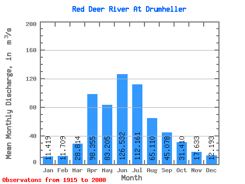
| Statistic | Jan | Feb | Mar | Apr | May | Jun | Jul | Aug | Sep | Oct | Nov | Dec | Annual |
|---|---|---|---|---|---|---|---|---|---|---|---|---|---|
| Mean | 11.42 | 11.71 | 28.81 | 98.36 | 83.20 | 126.53 | 112.16 | 65.11 | 45.08 | 31.41 | 17.63 | 12.19 | 53.27 |
| Standard Deviation | 4.79 | 4.96 | 22.89 | 71.92 | 67.81 | 88.84 | 78.58 | 40.23 | 38.13 | 19.08 | 7.47 | 5.25 | 23.22 |
| Min | 2.77 | 3.12 | 4.61 | 24.50 | 19.50 | 30.60 | 17.20 | 26.00 | 19.40 | 14.20 | 8.06 | 2.23 | 23.97 |
| Max | 19.90 | 20.80 | 102.00 | 308.00 | 404.00 | 405.00 | 362.00 | 274.00 | 280.00 | 123.00 | 47.40 | 24.80 | 145.88 |
| Coefficient of Variation | 0.42 | 0.42 | 0.79 | 0.73 | 0.81 | 0.70 | 0.70 | 0.62 | 0.85 | 0.61 | 0.42 | 0.43 | 0.44 |
 Return to R-Arctic Net Home Page