|
|
|||||||||||||||||
| Point ID: 38 | Downloads | Plots | Site Data | Code: 05AB020 |
|
|
|||||||||||||||||
| Download | |
|---|---|
| Site Descriptor Information | Site Time Series Data |
| Link to all available data | |
| View: | Time Series | All |
| Units: | mm |
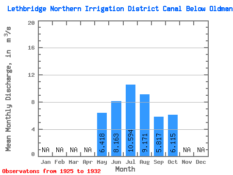
| Statistic | Jan | Feb | Mar | Apr | May | Jun | Jul | Aug | Sep | Oct | Nov | Dec | Annual |
|---|---|---|---|---|---|---|---|---|---|---|---|---|---|
| Mean | 6.42 | 8.16 | 10.59 | 9.17 | 5.82 | 6.12 | |||||||
| Standard Deviation | 3.68 | 5.17 | 5.58 | 3.68 | 2.04 | 2.68 | |||||||
| Min | 1.88 | 2.00 | 1.38 | 4.04 | 3.42 | 4.22 | |||||||
| Max | 10.90 | 14.80 | 18.40 | 13.40 | 8.71 | 8.01 | |||||||
| Coefficient of Variation | 0.57 | 0.63 | 0.53 | 0.40 | 0.35 | 0.44 |
 Return to R-Arctic Net Home Page