|
|
|||||||||||||||||
| Point ID: 375 | Downloads | Plots | Site Data | Code: 05CC007 |
|
|
|||||||||||||||||
| Download | |
|---|---|
| Site Descriptor Information | Site Time Series Data |
| Link to all available data | |
| View: | Time Series | All |
| Units: | mm |
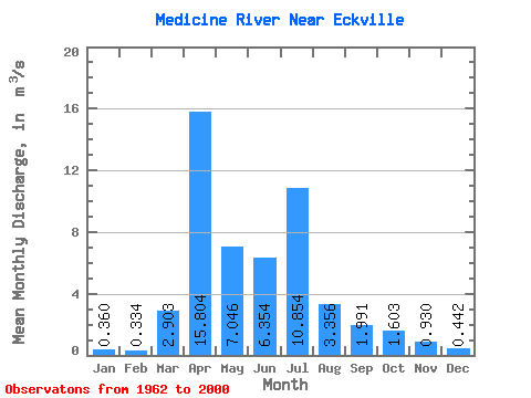
| Statistic | Jan | Feb | Mar | Apr | May | Jun | Jul | Aug | Sep | Oct | Nov | Dec | Annual |
|---|---|---|---|---|---|---|---|---|---|---|---|---|---|
| Mean | 0.36 | 0.33 | 2.90 | 15.80 | 7.05 | 6.35 | 10.85 | 3.36 | 1.99 | 1.60 | 0.93 | 0.44 | 4.15 |
| Standard Deviation | 0.14 | 0.14 | 3.57 | 11.47 | 5.32 | 7.08 | 12.59 | 3.25 | 2.19 | 1.23 | 0.67 | 0.18 | 2.15 |
| Min | 0.11 | 0.09 | 0.00 | 1.69 | 0.44 | 0.60 | 0.21 | 0.08 | 0.00 | 0.02 | 0.26 | 0.19 | 1.30 |
| Max | 0.63 | 0.64 | 12.30 | 44.30 | 21.00 | 30.30 | 46.00 | 12.50 | 9.56 | 5.44 | 3.79 | 0.87 | 9.38 |
| Coefficient of Variation | 0.39 | 0.41 | 1.23 | 0.73 | 0.76 | 1.11 | 1.16 | 0.97 | 1.10 | 0.77 | 0.72 | 0.41 | 0.52 |
 Return to R-Arctic Net Home Page