|
|
|||||||||||||||||
| Point ID: 373 | Downloads | Plots | Site Data | Code: 05CC002 |
|
|
|||||||||||||||||
| Download | |
|---|---|
| Site Descriptor Information | Site Time Series Data |
| Link to all available data | |
| View: | Time Series | All |
| Units: | mm |
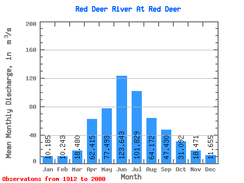
| Statistic | Jan | Feb | Mar | Apr | May | Jun | Jul | Aug | Sep | Oct | Nov | Dec | Annual |
|---|---|---|---|---|---|---|---|---|---|---|---|---|---|
| Mean | 10.19 | 10.24 | 18.48 | 62.41 | 77.49 | 123.64 | 101.83 | 64.17 | 47.43 | 31.09 | 18.47 | 11.65 | 47.91 |
| Standard Deviation | 4.34 | 4.17 | 13.14 | 40.93 | 54.85 | 78.70 | 70.89 | 41.80 | 42.33 | 19.73 | 9.22 | 5.46 | 20.14 |
| Min | 3.00 | 2.91 | 4.51 | 12.80 | 15.00 | 22.60 | 17.10 | 27.30 | 17.60 | 13.40 | 7.54 | 2.79 | 20.84 |
| Max | 21.00 | 19.90 | 73.20 | 205.00 | 383.00 | 392.00 | 474.00 | 252.00 | 293.00 | 111.00 | 51.90 | 24.90 | 124.23 |
| Coefficient of Variation | 0.43 | 0.41 | 0.71 | 0.66 | 0.71 | 0.64 | 0.70 | 0.65 | 0.89 | 0.64 | 0.50 | 0.47 | 0.42 |
 Return to R-Arctic Net Home Page