|
|
|||||||||||||||||
| Point ID: 371 | Downloads | Plots | Site Data | Code: 05CB007 |
|
|
|||||||||||||||||
| Download | |
|---|---|
| Site Descriptor Information | Site Time Series Data |
| Link to all available data | |
| View: | Time Series | All |
| Units: | mm |
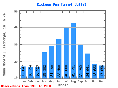
| Statistic | Jan | Feb | Mar | Apr | May | Jun | Jul | Aug | Sep | Oct | Nov | Dec | Annual |
|---|---|---|---|---|---|---|---|---|---|---|---|---|---|
| Mean | 17.05 | 16.79 | 16.93 | 25.38 | 29.10 | 33.40 | 40.00 | 42.73 | 29.77 | 24.64 | 18.68 | 17.66 | 25.19 |
| Standard Deviation | 1.06 | 1.11 | 1.01 | 9.76 | 12.11 | 17.97 | 19.34 | 12.68 | 10.32 | 10.81 | 2.68 | 1.51 | 4.12 |
| Min | 15.40 | 15.60 | 15.70 | 16.60 | 11.40 | 11.60 | 0.00 | 26.60 | 16.20 | 15.40 | 15.50 | 15.90 | 19.94 |
| Max | 19.70 | 20.10 | 19.90 | 48.70 | 46.40 | 69.50 | 60.00 | 64.90 | 53.70 | 63.00 | 26.50 | 21.30 | 31.37 |
| Coefficient of Variation | 0.06 | 0.07 | 0.06 | 0.38 | 0.42 | 0.54 | 0.48 | 0.30 | 0.35 | 0.44 | 0.14 | 0.09 | 0.16 |
 Return to R-Arctic Net Home Page