|
|
|||||||||||||||||
| Point ID: 37 | Downloads | Plots | Site Data | Code: 05AB019 |
|
|
|||||||||||||||||
| Download | |
|---|---|
| Site Descriptor Information | Site Time Series Data |
| Link to all available data | |
| View: | Time Series | All |
| Units: | mm |
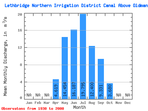
| Statistic | Jan | Feb | Mar | Apr | May | Jun | Jul | Aug | Sep | Oct | Nov | Dec | Annual |
|---|---|---|---|---|---|---|---|---|---|---|---|---|---|
| Mean | 4.62 | 14.45 | 16.19 | 19.80 | 12.40 | 9.33 | 3.68 | ||||||
| Standard Deviation | 3.29 | 8.09 | 6.85 | 9.49 | 4.57 | 4.66 | 2.36 | ||||||
| Min | 0.51 | 4.60 | 5.85 | 4.06 | 3.69 | 2.67 | 0.82 | ||||||
| Max | 11.40 | 30.60 | 26.30 | 34.10 | 22.10 | 18.60 | 11.10 | ||||||
| Coefficient of Variation | 0.71 | 0.56 | 0.42 | 0.48 | 0.37 | 0.50 | 0.64 |
 Return to R-Arctic Net Home Page