|
|
|||||||||||||||||
| Point ID: 3696 | Downloads | Plots | Site Data | Code: 10VC001 |
|
|
|||||||||||||||||
| Download | |
|---|---|
| Site Descriptor Information | Site Time Series Data |
| Link to all available data | |
| View: | Time Series | All |
| Units: | mm |
| Statistic | Jan | Feb | Mar | Apr | May | Jun | Jul | Aug | Sep | Oct | Nov | Dec | Annual |
|---|---|---|---|---|---|---|---|---|---|---|---|---|---|
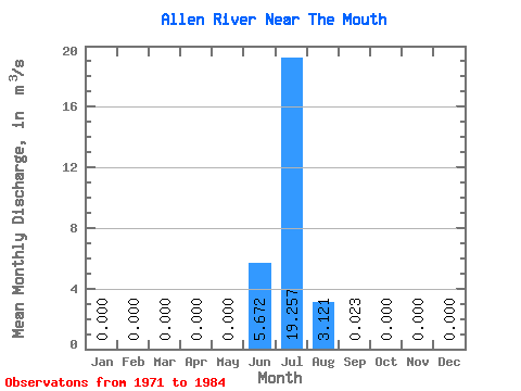
| Mean | 0.00 | 0.00 | 0.00 | 0.00 | 0.00 | 5.67 | 19.26 | 3.12 | 0.02 | 0.00 | 0.00 | 0.00 | 2.25 |
| Standard Deviation | 0.00 | 0.00 | 0.00 | 0.00 | 0.00 | 7.45 | 7.12 | 1.39 | 0.01 | 0.00 | 0.00 | 0.00 | 0.35 |
| Min | 0.00 | 0.00 | 0.00 | 0.00 | 0.00 | 0.00 | 5.20 | 1.23 | 0.01 | 0.00 | 0.00 | 0.00 | 1.85 |
| Max | 0.00 | 0.00 | 0.00 | 0.00 | 0.00 | 15.70 | 27.40 | 5.76 | 0.05 | 0.00 | 0.00 | 0.00 | 2.52 |
| Coefficient of Variation | 1.31 | 0.37 | 0.45 | 0.65 | 0.16 |
 Return to R-Arctic Net Home Page