|
|
|||||||||||||||||
| Point ID: 3674 | Downloads | Plots | Site Data | Code: 10OC001 |
|
|
|||||||||||||||||
| Download | |
|---|---|
| Site Descriptor Information | Site Time Series Data |
| Link to all available data | |
| View: | Time Series | All |
| Units: | mm |
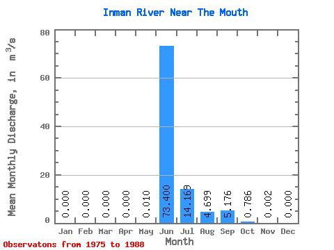
| Statistic | Jan | Feb | Mar | Apr | May | Jun | Jul | Aug | Sep | Oct | Nov | Dec | Annual |
|---|---|---|---|---|---|---|---|---|---|---|---|---|---|
| Mean | 0.00 | 0.00 | 0.00 | 0.00 | 0.01 | 73.40 | 14.17 | 4.70 | 5.18 | 0.79 | 0.00 | 0.00 | 7.66 |
| Standard Deviation | 0.00 | 0.00 | 0.00 | 0.00 | 0.03 | 37.92 | 6.28 | 2.75 | 4.68 | 0.96 | 0.00 | 0.00 | 3.38 |
| Min | 0.00 | 0.00 | 0.00 | 0.00 | 0.00 | 14.30 | 3.47 | 1.45 | 0.68 | 0.00 | 0.00 | 0.00 | 2.63 |
| Max | 0.00 | 0.00 | 0.00 | 0.00 | 0.09 | 119.00 | 26.20 | 9.05 | 11.50 | 3.01 | 0.01 | 0.00 | 12.51 |
| Coefficient of Variation | 2.56 | 0.52 | 0.44 | 0.58 | 0.90 | 1.22 | 1.80 | 0.44 |
 Return to R-Arctic Net Home Page