|
|
|||||||||||||||||
| Point ID: 3671 | Downloads | Plots | Site Data | Code: 10ND003 |
|
|
|||||||||||||||||
| Download | |
|---|---|
| Site Descriptor Information | Site Time Series Data |
| Link to all available data | |
| View: | Time Series | All |
| Units: | mm |
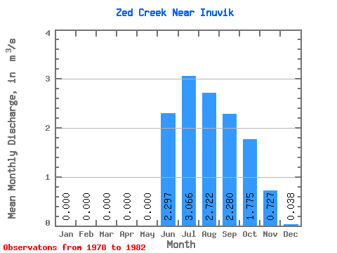
| Statistic | Jan | Feb | Mar | Apr | May | Jun | Jul | Aug | Sep | Oct | Nov | Dec | Annual |
|---|---|---|---|---|---|---|---|---|---|---|---|---|---|
| Mean | 0.00 | 0.00 | 0.00 | 0.00 | 0.00 | 2.30 | 3.07 | 2.72 | 2.28 | 1.77 | 0.73 | 0.04 | 1.04 |
| Standard Deviation | 0.00 | 0.00 | 0.00 | 0.00 | 0.00 | 0.47 | 0.84 | 0.64 | 0.33 | 0.25 | 0.39 | 0.04 | 0.16 |
| Min | 0.00 | 0.00 | 0.00 | 0.00 | 0.00 | 1.91 | 2.05 | 1.67 | 1.76 | 1.53 | 0.16 | 0.01 | 0.85 |
| Max | 0.00 | 0.00 | 0.00 | 0.00 | 0.00 | 2.96 | 3.99 | 3.25 | 2.56 | 2.09 | 1.02 | 0.10 | 1.18 |
| Coefficient of Variation | 0.20 | 0.28 | 0.24 | 0.14 | 0.14 | 0.54 | 1.18 | 0.15 |
 Return to R-Arctic Net Home Page