|
|
|||||||||||||||||
| Point ID: 3660 | Downloads | Plots | Site Data | Code: 10LC014 |
|
|
|||||||||||||||||
| Download | |
|---|---|
| Site Descriptor Information | Site Time Series Data |
| Link to all available data | |
| View: | Time Series | All |
| Units: | mm |
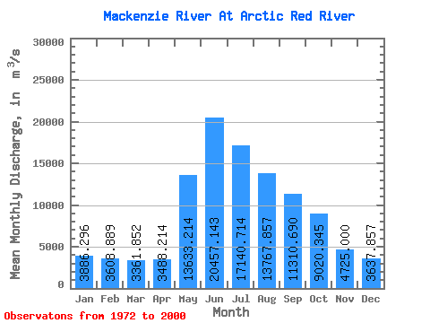
| Statistic | Jan | Feb | Mar | Apr | May | Jun | Jul | Aug | Sep | Oct | Nov | Dec | Annual |
|---|---|---|---|---|---|---|---|---|---|---|---|---|---|
| Mean | 3886.30 | 3608.89 | 3361.85 | 3488.21 | 13633.21 | 20457.14 | 17140.71 | 13767.86 | 11310.69 | 9020.34 | 4725.00 | 3637.86 | 8926.28 |
| Standard Deviation | 647.30 | 505.34 | 526.70 | 705.83 | 3154.07 | 3290.21 | 3530.97 | 2698.14 | 1844.41 | 1222.34 | 1040.65 | 738.71 | 985.30 |
| Min | 2470.00 | 2810.00 | 2450.00 | 2180.00 | 7210.00 | 11100.00 | 8940.00 | 9220.00 | 8120.00 | 6760.00 | 3260.00 | 2130.00 | 6514.17 |
| Max | 5720.00 | 4900.00 | 4550.00 | 5640.00 | 21000.00 | 27700.00 | 26000.00 | 21800.00 | 15000.00 | 11600.00 | 8210.00 | 5300.00 | 10612.50 |
| Coefficient of Variation | 0.17 | 0.14 | 0.16 | 0.20 | 0.23 | 0.16 | 0.21 | 0.20 | 0.16 | 0.14 | 0.22 | 0.20 | 0.11 |
 Return to R-Arctic Net Home Page