|
|
|||||||||||||||||
| Point ID: 3656 | Downloads | Plots | Site Data | Code: 10LC007 |
|
|
|||||||||||||||||
| Download | |
|---|---|
| Site Descriptor Information | Site Time Series Data |
| Link to all available data | |
| View: | Time Series | All |
| Units: | mm |
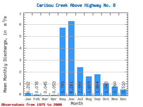
| Statistic | Jan | Feb | Mar | Apr | May | Jun | Jul | Aug | Sep | Oct | Nov | Dec | Annual |
|---|---|---|---|---|---|---|---|---|---|---|---|---|---|
| Mean | 0.20 | 0.08 | 0.04 | 0.05 | 5.75 | 6.28 | 2.39 | 1.61 | 1.80 | 1.04 | 0.76 | 0.51 | 1.75 |
| Standard Deviation | 0.26 | 0.22 | 0.16 | 0.15 | 4.20 | 3.57 | 1.48 | 0.94 | 0.82 | 0.53 | 0.48 | 0.44 | 0.68 |
| Min | 0.00 | 0.00 | 0.00 | 0.00 | 0.07 | 2.42 | 0.66 | 0.61 | 0.59 | 0.26 | 0.02 | 0.00 | 0.75 |
| Max | 0.80 | 0.93 | 0.70 | 0.56 | 17.10 | 16.70 | 6.90 | 5.10 | 3.68 | 2.34 | 2.47 | 1.99 | 3.29 |
| Coefficient of Variation | 1.27 | 2.87 | 3.53 | 2.78 | 0.73 | 0.57 | 0.62 | 0.59 | 0.45 | 0.50 | 0.63 | 0.86 | 0.39 |
 Return to R-Arctic Net Home Page