|
|
|||||||||||||||||
| Point ID: 3652 | Downloads | Plots | Site Data | Code: 10LC002 |
|
|
|||||||||||||||||
| Download | |
|---|---|
| Site Descriptor Information | Site Time Series Data |
| Link to all available data | |
| View: | Time Series | All |
| Units: | mm |
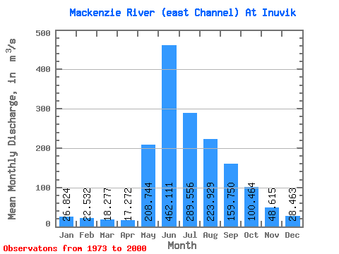
| Statistic | Jan | Feb | Mar | Apr | May | Jun | Jul | Aug | Sep | Oct | Nov | Dec | Annual |
|---|---|---|---|---|---|---|---|---|---|---|---|---|---|
| Mean | 26.82 | 22.53 | 18.28 | 17.27 | 208.74 | 462.11 | 289.56 | 223.93 | 159.75 | 100.46 | 48.62 | 28.46 | 132.06 |
| Standard Deviation | 14.34 | 11.79 | 11.32 | 10.66 | 102.64 | 116.31 | 71.70 | 59.79 | 37.21 | 25.89 | 22.89 | 13.09 | 20.36 |
| Min | 2.57 | 5.02 | 2.68 | 0.49 | 69.00 | 200.00 | 137.00 | 141.00 | 103.00 | 60.50 | 19.10 | 10.00 | 88.68 |
| Max | 69.40 | 51.80 | 45.60 | 44.30 | 421.00 | 745.00 | 487.00 | 408.00 | 225.00 | 169.00 | 116.00 | 65.30 | 168.86 |
| Coefficient of Variation | 0.54 | 0.52 | 0.62 | 0.62 | 0.49 | 0.25 | 0.25 | 0.27 | 0.23 | 0.26 | 0.47 | 0.46 | 0.15 |
 Return to R-Arctic Net Home Page