|
|
|||||||||||||||||
| Point ID: 364 | Downloads | Plots | Site Data | Code: 05CA009 |
|
|
|||||||||||||||||
| Download | |
|---|---|
| Site Descriptor Information | Site Time Series Data |
| Link to all available data | |
| View: | Time Series | All |
| Units: | mm |
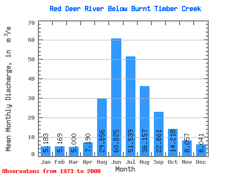
| Statistic | Jan | Feb | Mar | Apr | May | Jun | Jul | Aug | Sep | Oct | Nov | Dec | Annual |
|---|---|---|---|---|---|---|---|---|---|---|---|---|---|
| Mean | 5.18 | 5.17 | 5.00 | 7.19 | 29.86 | 60.83 | 51.54 | 36.16 | 22.86 | 14.22 | 8.06 | 6.04 | 20.84 |
| Standard Deviation | 1.00 | 0.89 | 0.93 | 1.12 | 14.16 | 25.16 | 20.34 | 10.97 | 5.59 | 4.03 | 1.77 | 1.33 | 4.80 |
| Min | 3.42 | 3.42 | 3.39 | 5.62 | 11.90 | 27.90 | 25.40 | 23.80 | 15.10 | 10.40 | 4.98 | 3.48 | 14.36 |
| Max | 7.41 | 6.87 | 7.49 | 10.20 | 65.40 | 124.00 | 101.00 | 67.10 | 37.30 | 31.50 | 14.50 | 10.10 | 30.40 |
| Coefficient of Variation | 0.19 | 0.17 | 0.18 | 0.16 | 0.47 | 0.41 | 0.40 | 0.30 | 0.24 | 0.28 | 0.22 | 0.22 | 0.23 |
 Return to R-Arctic Net Home Page