|
|
|||||||||||||||||
| Point ID: 3632 | Downloads | Plots | Site Data | Code: 10HC003 |
|
|
|||||||||||||||||
| Download | |
|---|---|
| Site Descriptor Information | Site Time Series Data |
| Link to all available data | |
| View: | Time Series | All |
| Units: | mm |
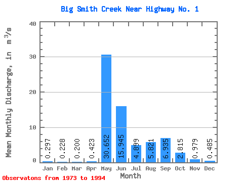
| Statistic | Jan | Feb | Mar | Apr | May | Jun | Jul | Aug | Sep | Oct | Nov | Dec | Annual |
|---|---|---|---|---|---|---|---|---|---|---|---|---|---|
| Mean | 0.30 | 0.23 | 0.20 | 0.42 | 30.65 | 15.95 | 4.90 | 5.82 | 6.94 | 2.81 | 0.98 | 0.48 | 5.83 |
| Standard Deviation | 0.13 | 0.12 | 0.13 | 0.40 | 9.82 | 9.59 | 3.41 | 8.17 | 11.26 | 1.69 | 0.42 | 0.16 | 2.19 |
| Min | 0.01 | 0.00 | 0.00 | 0.07 | 13.20 | 2.99 | 1.44 | 0.73 | 0.59 | 0.75 | 0.47 | 0.14 | 2.72 |
| Max | 0.57 | 0.51 | 0.46 | 1.86 | 46.30 | 31.70 | 15.60 | 30.00 | 44.00 | 6.89 | 1.99 | 0.81 | 10.72 |
| Coefficient of Variation | 0.45 | 0.55 | 0.64 | 0.94 | 0.32 | 0.60 | 0.69 | 1.40 | 1.62 | 0.60 | 0.43 | 0.32 | 0.38 |
 Return to R-Arctic Net Home Page