|
|
|||||||||||||||||
| Point ID: 3617 | Downloads | Plots | Site Data | Code: 10FC001 |
|
|
|||||||||||||||||
| Download | |
|---|---|
| Site Descriptor Information | Site Time Series Data |
| Link to all available data | |
| View: | Time Series | All |
| Units: | mm |
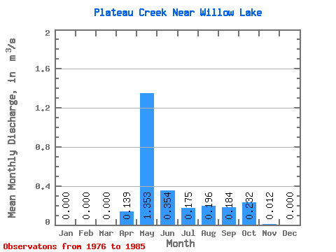
| Statistic | Jan | Feb | Mar | Apr | May | Jun | Jul | Aug | Sep | Oct | Nov | Dec | Annual |
|---|---|---|---|---|---|---|---|---|---|---|---|---|---|
| Mean | 0.00 | 0.00 | 0.00 | 0.14 | 1.35 | 0.35 | 0.17 | 0.20 | 0.18 | 0.23 | 0.01 | 0.00 | 0.23 |
| Standard Deviation | 0.00 | 0.00 | 0.00 | 0.26 | 0.53 | 0.28 | 0.15 | 0.30 | 0.19 | 0.17 | 0.01 | 0.00 | 0.09 |
| Min | 0.00 | 0.00 | 0.00 | 0.00 | 0.53 | 0.03 | 0.01 | 0.00 | 0.02 | 0.02 | 0.00 | 0.00 | 0.15 |
| Max | 0.00 | 0.00 | 0.00 | 0.61 | 2.01 | 1.06 | 0.40 | 0.82 | 0.59 | 0.58 | 0.02 | 0.00 | 0.39 |
| Coefficient of Variation | 1.85 | 0.39 | 0.81 | 0.88 | 1.55 | 1.05 | 0.75 | 0.58 | 0.37 |
 Return to R-Arctic Net Home Page