|
|
|||||||||||||||||
| Point ID: 3590 | Downloads | Plots | Site Data | Code: 07SB013 |
|
|
|||||||||||||||||
| Download | |
|---|---|
| Site Descriptor Information | Site Time Series Data |
| Link to all available data | |
| View: | Time Series | All |
| Units: | mm |
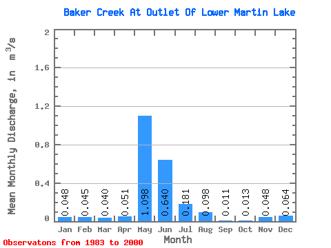
| Statistic | Jan | Feb | Mar | Apr | May | Jun | Jul | Aug | Sep | Oct | Nov | Dec | Annual |
|---|---|---|---|---|---|---|---|---|---|---|---|---|---|
| Mean | 0.05 | 0.04 | 0.04 | 0.05 | 1.10 | 0.64 | 0.18 | 0.10 | 0.01 | 0.01 | 0.05 | 0.06 | 0.21 |
| Standard Deviation | 0.08 | 0.06 | 0.06 | 0.06 | 1.12 | 0.63 | 0.46 | 0.34 | 0.02 | 0.02 | 0.08 | 0.08 | 0.17 |
| Min | 0.00 | 0.00 | 0.00 | 0.00 | 0.08 | 0.03 | 0.00 | 0.00 | 0.00 | 0.00 | 0.00 | 0.00 | 0.03 |
| Max | 0.26 | 0.19 | 0.16 | 0.20 | 3.93 | 2.31 | 1.93 | 1.38 | 0.08 | 0.06 | 0.28 | 0.25 | 0.59 |
| Coefficient of Variation | 1.66 | 1.43 | 1.41 | 1.25 | 1.02 | 0.98 | 2.51 | 3.48 | 2.01 | 1.48 | 1.67 | 1.30 | 0.81 |
 Return to R-Arctic Net Home Page