|
|
|||||||||||||||||
| Point ID: 3581 | Downloads | Plots | Site Data | Other Close Sites | Code: 07SB002 |
|
|
|||||||||||||||||
| Download | |
|---|---|
| Site Descriptor Information | Site Time Series Data |
| Link to all available data | |
| View: | Time Series | All |
| Units: | mm |
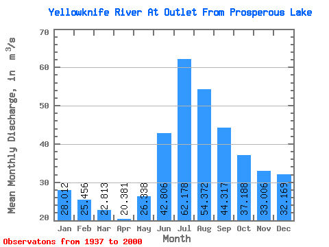
| Statistic | Jan | Feb | Mar | Apr | May | Jun | Jul | Aug | Sep | Oct | Nov | Dec | Annual |
|---|---|---|---|---|---|---|---|---|---|---|---|---|---|
| Mean | 28.01 | 25.46 | 22.81 | 20.38 | 26.34 | 42.81 | 62.18 | 54.37 | 44.32 | 37.19 | 33.01 | 32.17 | 37.89 |
| Standard Deviation | 10.37 | 8.77 | 7.04 | 5.96 | 11.25 | 34.49 | 50.72 | 35.38 | 22.76 | 17.13 | 14.66 | 11.37 | 14.32 |
| Min | 13.60 | 13.60 | 12.60 | 12.00 | 12.80 | 15.40 | 15.20 | 15.80 | 15.90 | 15.50 | 11.10 | 13.90 | 17.73 |
| Max | 49.70 | 42.80 | 35.40 | 29.50 | 47.40 | 150.00 | 199.00 | 123.00 | 96.70 | 77.10 | 67.60 | 58.70 | 69.46 |
| Coefficient of Variation | 0.37 | 0.34 | 0.31 | 0.29 | 0.43 | 0.81 | 0.82 | 0.65 | 0.51 | 0.46 | 0.44 | 0.35 | 0.38 |
| Other Close Sites | ||||||
|---|---|---|---|---|---|---|
| PointID | Latitude | Longitude | Drainage Area | Source | Name | |
| 3582 | "YELLOWKNIFE RIVER AT INLET TO PROSPEROUS LAKE" | 62.67 | 1236881 | Hydat | ||
| 3585 | "YELLOWKNIFE RIVER POWER DIVERSION AT SITE Y2" | 62.66 | 1236846 | Hydat | ||
 Return to R-Arctic Net Home Page