|
|
|||||||||||||||||
| Point ID: 3567 | Downloads | Plots | Site Data | Code: 07QB002 |
|
|
|||||||||||||||||
| Download | |
|---|---|
| Site Descriptor Information | Site Time Series Data |
| Link to all available data | |
| View: | Time Series | All |
| Units: | mm |
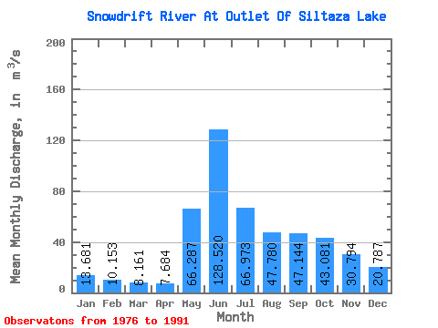
| Statistic | Jan | Feb | Mar | Apr | May | Jun | Jul | Aug | Sep | Oct | Nov | Dec | Annual |
|---|---|---|---|---|---|---|---|---|---|---|---|---|---|
| Mean | 13.68 | 10.15 | 8.16 | 7.68 | 66.29 | 128.52 | 66.97 | 47.78 | 47.14 | 43.08 | 30.79 | 20.79 | 41.52 |
| Standard Deviation | 5.29 | 3.39 | 2.28 | 2.64 | 37.72 | 63.06 | 27.06 | 19.24 | 24.34 | 23.59 | 14.06 | 8.86 | 11.72 |
| Min | 6.79 | 5.52 | 4.68 | 3.89 | 11.10 | 33.50 | 19.20 | 14.50 | 18.00 | 15.30 | 13.20 | 9.64 | 19.90 |
| Max | 21.10 | 15.10 | 11.30 | 14.80 | 127.00 | 328.00 | 144.00 | 86.60 | 92.70 | 82.50 | 56.10 | 37.90 | 70.90 |
| Coefficient of Variation | 0.39 | 0.33 | 0.28 | 0.34 | 0.57 | 0.49 | 0.40 | 0.40 | 0.52 | 0.55 | 0.46 | 0.43 | 0.28 |
 Return to R-Arctic Net Home Page