|
|
|||||||||||||||||
| Point ID: 3564 | Downloads | Plots | Site Data | Code: 07PB002 |
|
|
|||||||||||||||||
| Download | |
|---|---|
| Site Descriptor Information | Site Time Series Data |
| Link to all available data | |
| View: | Time Series | All |
| Units: | mm |
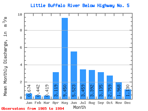
| Statistic | Jan | Feb | Mar | Apr | May | Jun | Jul | Aug | Sep | Oct | Nov | Dec | Annual |
|---|---|---|---|---|---|---|---|---|---|---|---|---|---|
| Mean | 0.67 | 0.44 | 0.42 | 3.12 | 9.45 | 5.52 | 3.46 | 3.39 | 3.13 | 2.76 | 1.97 | 1.13 | 3.39 |
| Standard Deviation | 0.63 | 0.37 | 0.34 | 2.50 | 7.89 | 4.50 | 3.67 | 4.35 | 4.30 | 3.04 | 1.78 | 0.91 | 2.51 |
| Min | 0.00 | 0.00 | 0.00 | 0.59 | 0.73 | 0.25 | 0.06 | 0.03 | 0.10 | 0.14 | 0.12 | 0.00 | 0.60 |
| Max | 1.53 | 0.97 | 0.82 | 8.98 | 27.30 | 16.70 | 15.90 | 16.50 | 14.90 | 11.70 | 5.19 | 2.43 | 6.71 |
| Coefficient of Variation | 0.93 | 0.85 | 0.82 | 0.80 | 0.83 | 0.82 | 1.06 | 1.28 | 1.37 | 1.10 | 0.91 | 0.81 | 0.74 |
 Return to R-Arctic Net Home Page