|
|
|||||||||||||||||
| Point ID: 356 | Downloads | Plots | Site Data | Code: 05BN017 |
|
|
|||||||||||||||||
| Download | |
|---|---|
| Site Descriptor Information | Site Time Series Data |
| Link to all available data | |
| View: | Time Series | All |
| Units: | mm |
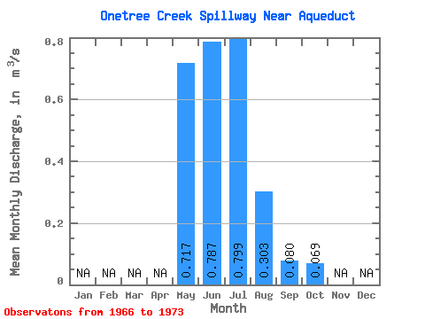
| Statistic | Jan | Feb | Mar | Apr | May | Jun | Jul | Aug | Sep | Oct | Nov | Dec | Annual |
|---|---|---|---|---|---|---|---|---|---|---|---|---|---|
| Mean | 0.72 | 0.79 | 0.80 | 0.30 | 0.08 | 0.07 | |||||||
| Standard Deviation | 0.36 | 0.22 | 0.38 | 0.14 | 0.06 | 0.04 | |||||||
| Min | 0.07 | 0.48 | 0.17 | 0.08 | 0.01 | 0.00 | |||||||
| Max | 1.29 | 1.22 | 1.38 | 0.51 | 0.17 | 0.14 | |||||||
| Coefficient of Variation | 0.50 | 0.27 | 0.48 | 0.47 | 0.69 | 0.61 |
 Return to R-Arctic Net Home Page