|
|
|||||||||||||||||
| Point ID: 354 | Downloads | Plots | Site Data | Code: 05BN015 |
|
|
|||||||||||||||||
| Download | |
|---|---|
| Site Descriptor Information | Site Time Series Data |
| Link to all available data | |
| View: | Time Series | All |
| Units: | mm |
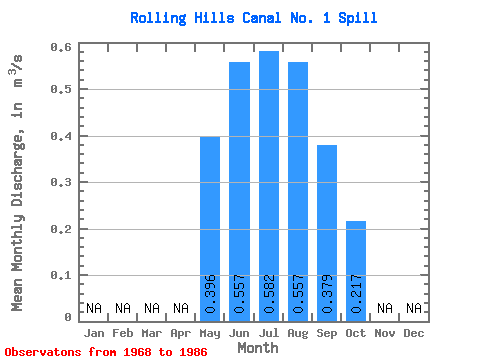
| Statistic | Jan | Feb | Mar | Apr | May | Jun | Jul | Aug | Sep | Oct | Nov | Dec | Annual |
|---|---|---|---|---|---|---|---|---|---|---|---|---|---|
| Mean | 0.40 | 0.56 | 0.58 | 0.56 | 0.38 | 0.22 | |||||||
| Standard Deviation | 0.24 | 0.34 | 0.33 | 0.31 | 0.24 | 0.17 | |||||||
| Min | 0.02 | 0.09 | 0.13 | 0.14 | 0.16 | 0.04 | |||||||
| Max | 1.00 | 1.30 | 1.30 | 1.38 | 1.18 | 0.65 | |||||||
| Coefficient of Variation | 0.61 | 0.60 | 0.57 | 0.56 | 0.65 | 0.79 |
 Return to R-Arctic Net Home Page