|
|
|||||||||||||||||
| Point ID: 3537 | Downloads | Plots | Site Data | Code: 06MA002 |
|
|
|||||||||||||||||
| Download | |
|---|---|
| Site Descriptor Information | Site Time Series Data |
| Link to all available data | |
| View: | Time Series | All |
| Units: | mm |
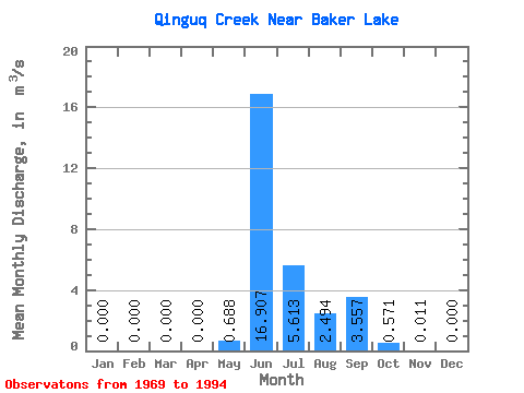
| Statistic | Jan | Feb | Mar | Apr | May | Jun | Jul | Aug | Sep | Oct | Nov | Dec | Annual |
|---|---|---|---|---|---|---|---|---|---|---|---|---|---|
| Mean | 0.00 | 0.00 | 0.00 | 0.00 | 0.69 | 16.91 | 5.61 | 2.49 | 3.56 | 0.57 | 0.01 | 0.00 | 2.64 |
| Standard Deviation | 0.00 | 0.00 | 0.00 | 0.00 | 1.92 | 8.01 | 2.92 | 2.27 | 3.72 | 0.76 | 0.03 | 0.00 | 0.88 |
| Min | 0.00 | 0.00 | 0.00 | 0.00 | 0.00 | 6.44 | 1.15 | 0.34 | 0.15 | 0.00 | 0.00 | 0.00 | 1.42 |
| Max | 0.00 | 0.00 | 0.00 | 0.00 | 8.05 | 37.30 | 12.20 | 9.62 | 17.10 | 3.18 | 0.16 | 0.00 | 4.20 |
| Coefficient of Variation | 2.79 | 0.47 | 0.52 | 0.91 | 1.05 | 1.33 | 3.10 | 0.33 |
 Return to R-Arctic Net Home Page