|
|
|||||||||||||||||
| Point ID: 3526 | Downloads | Plots | Site Data | Code: 06HD001 |
|
|
|||||||||||||||||
| Download | |
|---|---|
| Site Descriptor Information | Site Time Series Data |
| Link to all available data | |
| View: | Time Series | All |
| Units: | mm |
| Statistic | Jan | Feb | Mar | Apr | May | Jun | Jul | Aug | Sep | Oct | Nov | Dec | Annual |
|---|---|---|---|---|---|---|---|---|---|---|---|---|---|
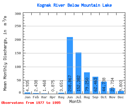
| Mean | 4.94 | 2.44 | 1.47 | 0.88 | 3.65 | 208.87 | 152.38 | 79.25 | 62.46 | 44.74 | 20.73 | 9.80 | 50.67 |
| Standard Deviation | 3.62 | 1.23 | 0.75 | 0.43 | 6.12 | 52.76 | 52.99 | 34.63 | 38.38 | 18.10 | 12.12 | 7.06 | 10.26 |
| Min | 0.00 | 0.00 | 0.00 | 0.00 | 0.07 | 120.00 | 52.40 | 42.20 | 32.70 | 27.60 | 6.34 | 1.04 | 34.85 |
| Max | 14.90 | 4.81 | 2.58 | 1.81 | 18.30 | 285.00 | 230.00 | 195.00 | 192.00 | 94.00 | 44.20 | 24.00 | 73.93 |
| Coefficient of Variation | 0.73 | 0.51 | 0.51 | 0.49 | 1.68 | 0.25 | 0.35 | 0.44 | 0.61 | 0.41 | 0.58 | 0.72 | 0.20 |
 Return to R-Arctic Net Home Page