|
|
|||||||||||||||||
| Point ID: 344 | Downloads | Plots | Site Data | Code: 05BN005 |
|
|
|||||||||||||||||
| Download | |
|---|---|
| Site Descriptor Information | Site Time Series Data |
| Link to all available data | |
| View: | Time Series | All |
| Units: | mm |
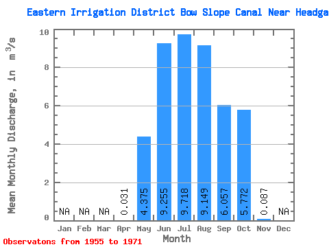
| Statistic | Jan | Feb | Mar | Apr | May | Jun | Jul | Aug | Sep | Oct | Nov | Dec | Annual |
|---|---|---|---|---|---|---|---|---|---|---|---|---|---|
| Mean | 0.03 | 4.38 | 9.26 | 9.72 | 9.15 | 6.06 | 5.77 | 0.09 | |||||
| Standard Deviation | 0.05 | 2.63 | 2.26 | 1.74 | 2.14 | 2.64 | 1.92 | 0.12 | |||||
| Min | 0.00 | 0.32 | 3.87 | 5.92 | 3.28 | 1.28 | 3.27 | 0.00 | |||||
| Max | 0.09 | 8.76 | 12.20 | 12.60 | 11.90 | 9.86 | 9.94 | 0.17 | |||||
| Coefficient of Variation | 1.70 | 0.60 | 0.24 | 0.18 | 0.23 | 0.44 | 0.33 | 1.41 |
 Return to R-Arctic Net Home Page