|
|
|||||||||||||||||
| Point ID: 343 | Downloads | Plots | Site Data | Code: 05BN004 |
|
|
|||||||||||||||||
| Download | |
|---|---|
| Site Descriptor Information | Site Time Series Data |
| Link to all available data | |
| View: | Time Series | All |
| Units: | mm |
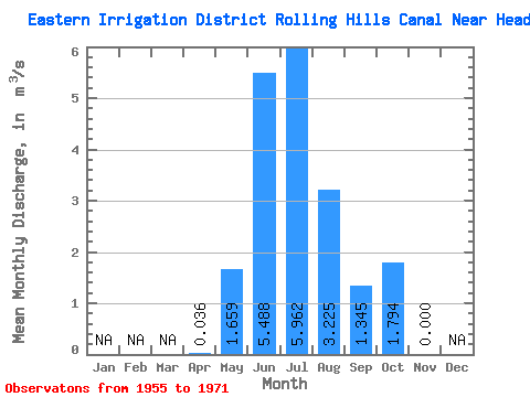
| Statistic | Jan | Feb | Mar | Apr | May | Jun | Jul | Aug | Sep | Oct | Nov | Dec | Annual |
|---|---|---|---|---|---|---|---|---|---|---|---|---|---|
| Mean | 0.04 | 1.66 | 5.49 | 5.96 | 3.23 | 1.34 | 1.79 | 0.00 | |||||
| Standard Deviation | 0.05 | 1.30 | 1.95 | 1.67 | 0.94 | 0.56 | 0.78 | ||||||
| Min | 0.00 | 0.32 | 1.98 | 2.25 | 1.62 | 0.55 | 0.90 | 0.00 | |||||
| Max | 0.07 | 5.22 | 8.08 | 8.00 | 4.77 | 2.34 | 3.45 | 0.00 | |||||
| Coefficient of Variation | 1.41 | 0.78 | 0.36 | 0.28 | 0.29 | 0.42 | 0.43 |
 Return to R-Arctic Net Home Page