|
|
|||||||||||||||||
| Point ID: 341 | Downloads | Plots | Site Data | Code: 05BN002 |
|
|
|||||||||||||||||
| Download | |
|---|---|
| Site Descriptor Information | Site Time Series Data |
| Link to all available data | |
| View: | Time Series | All |
| Units: | mm |
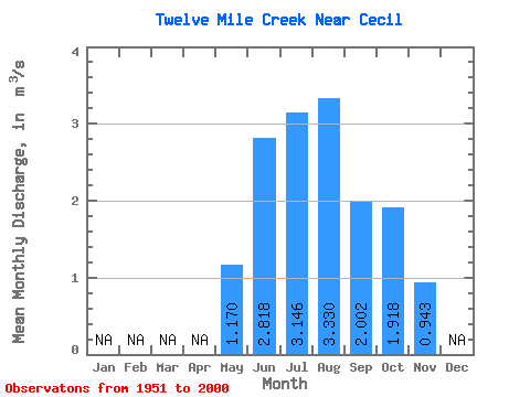
| Statistic | Jan | Feb | Mar | Apr | May | Jun | Jul | Aug | Sep | Oct | Nov | Dec | Annual |
|---|---|---|---|---|---|---|---|---|---|---|---|---|---|
| Mean | 1.17 | 2.82 | 3.15 | 3.33 | 2.00 | 1.92 | 0.94 | ||||||
| Standard Deviation | 1.07 | 1.60 | 1.93 | 1.31 | 0.70 | 0.46 | 0.56 | ||||||
| Min | 0.04 | 0.43 | 0.50 | 1.08 | 0.83 | 1.03 | 0.55 | ||||||
| Max | 4.72 | 5.92 | 6.99 | 5.99 | 3.80 | 3.04 | 1.34 | ||||||
| Coefficient of Variation | 0.92 | 0.57 | 0.61 | 0.39 | 0.35 | 0.24 | 0.59 |
 Return to R-Arctic Net Home Page