|
|
|||||||||||||||||
| Point ID: 338 | Downloads | Plots | Site Data | Code: 05BM017 |
|
|
|||||||||||||||||
| Download | |
|---|---|
| Site Descriptor Information | Site Time Series Data |
| Link to all available data | |
| View: | Time Series | All |
| Units: | mm |
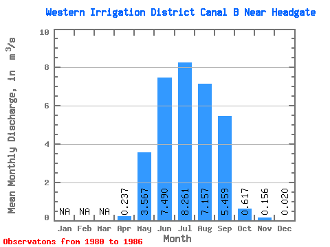
| Statistic | Jan | Feb | Mar | Apr | May | Jun | Jul | Aug | Sep | Oct | Nov | Dec | Annual |
|---|---|---|---|---|---|---|---|---|---|---|---|---|---|
| Mean | 0.24 | 3.57 | 7.49 | 8.26 | 7.16 | 5.46 | 0.62 | 0.16 | 0.02 | ||||
| Standard Deviation | 0.21 | 0.97 | 2.02 | 2.17 | 1.51 | 0.78 | 0.53 | 0.12 | 0.01 | ||||
| Min | 0.05 | 2.51 | 4.30 | 5.33 | 5.16 | 4.33 | 0.02 | 0.03 | 0.01 | ||||
| Max | 0.59 | 4.82 | 10.60 | 11.00 | 9.70 | 6.50 | 1.30 | 0.35 | 0.03 | ||||
| Coefficient of Variation | 0.88 | 0.27 | 0.27 | 0.26 | 0.21 | 0.14 | 0.85 | 0.80 | 0.62 |
 Return to R-Arctic Net Home Page