|
|
|||||||||||||||||
| Point ID: 333 | Downloads | Plots | Site Data | Code: 05BM011 |
|
|
|||||||||||||||||
| Download | |
|---|---|
| Site Descriptor Information | Site Time Series Data |
| Link to all available data | |
| View: | Time Series | All |
| Units: | mm |
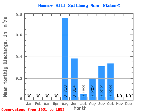
| Statistic | Jan | Feb | Mar | Apr | May | Jun | Jul | Aug | Sep | Oct | Nov | Dec | Annual |
|---|---|---|---|---|---|---|---|---|---|---|---|---|---|
| Mean | 0.76 | 0.38 | 0.05 | 0.20 | 0.31 | 0.34 | |||||||
| Standard Deviation | 1.06 | 0.51 | 0.07 | 0.28 | 0.37 | 0.43 | |||||||
| Min | 0.01 | 0.03 | 0.00 | 0.00 | 0.03 | 0.00 | |||||||
| Max | 1.51 | 0.74 | 0.10 | 0.40 | 0.73 | 0.83 | |||||||
| Coefficient of Variation | 1.40 | 1.31 | 1.33 | 1.39 | 1.18 | 1.28 |
 Return to R-Arctic Net Home Page