|
|
|||||||||||||||||
| Point ID: 332 | Downloads | Plots | Site Data | Code: 05BM010 |
|
|
|||||||||||||||||
| Download | |
|---|---|
| Site Descriptor Information | Site Time Series Data |
| Link to all available data | |
| View: | Time Series | All |
| Units: | mm |
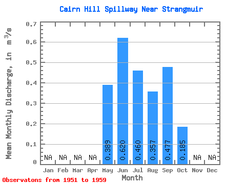
| Statistic | Jan | Feb | Mar | Apr | May | Jun | Jul | Aug | Sep | Oct | Nov | Dec | Annual |
|---|---|---|---|---|---|---|---|---|---|---|---|---|---|
| Mean | 0.39 | 0.62 | 0.46 | 0.36 | 0.48 | 0.18 | |||||||
| Standard Deviation | 0.25 | 0.29 | 0.27 | 0.19 | 0.37 | 0.09 | |||||||
| Min | 0.13 | 0.14 | 0.10 | 0.04 | 0.03 | 0.03 | |||||||
| Max | 0.91 | 1.10 | 0.83 | 0.68 | 0.99 | 0.31 | |||||||
| Coefficient of Variation | 0.64 | 0.46 | 0.59 | 0.54 | 0.78 | 0.48 |
 Return to R-Arctic Net Home Page