|
|
|||||||||||||||||
| Point ID: 328 | Downloads | Plots | Site Data | Code: 05BM006 |
|
|
|||||||||||||||||
| Download | |
|---|---|
| Site Descriptor Information | Site Time Series Data |
| Link to all available data | |
| View: | Time Series | All |
| Units: | mm |
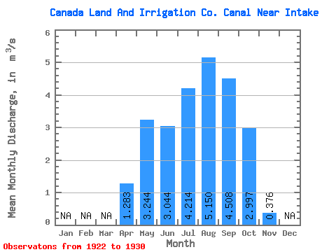
| Statistic | Jan | Feb | Mar | Apr | May | Jun | Jul | Aug | Sep | Oct | Nov | Dec | Annual |
|---|---|---|---|---|---|---|---|---|---|---|---|---|---|
| Mean | 1.28 | 3.24 | 3.04 | 4.21 | 5.15 | 4.51 | 3.00 | 0.38 | |||||
| Standard Deviation | 1.87 | 2.93 | 2.51 | 2.49 | 2.88 | 2.71 | 3.10 | 0.64 | |||||
| Min | 0.00 | 0.00 | 0.38 | 0.46 | 0.59 | 0.00 | 0.00 | 0.00 | |||||
| Max | 5.47 | 7.21 | 6.64 | 7.13 | 7.59 | 7.22 | 7.15 | 1.40 | |||||
| Coefficient of Variation | 1.46 | 0.90 | 0.82 | 0.59 | 0.56 | 0.60 | 1.03 | 1.71 |
 Return to R-Arctic Net Home Page