|
|
|||||||||||||||||
| Point ID: 327 | Downloads | Plots | Site Data | Code: 05BM005 |
|
|
|||||||||||||||||
| Download | |
|---|---|
| Site Descriptor Information | Site Time Series Data |
| Link to all available data | |
| View: | Time Series | All |
| Units: | mm |
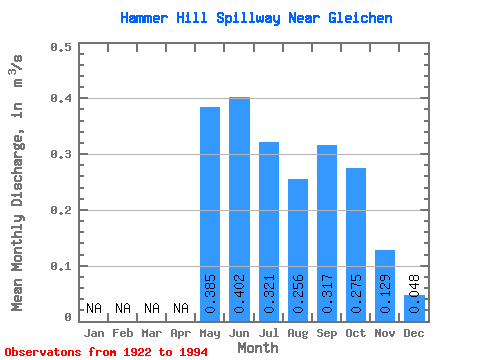
| Statistic | Jan | Feb | Mar | Apr | May | Jun | Jul | Aug | Sep | Oct | Nov | Dec | Annual |
|---|---|---|---|---|---|---|---|---|---|---|---|---|---|
| Mean | 0.39 | 0.40 | 0.32 | 0.26 | 0.32 | 0.28 | 0.13 | 0.05 | |||||
| Standard Deviation | 0.41 | 0.41 | 0.28 | 0.26 | 0.26 | 0.21 | 0.12 | 0.05 | |||||
| Min | 0.01 | 0.03 | 0.03 | 0.00 | 0.01 | 0.00 | 0.00 | 0.01 | |||||
| Max | 1.41 | 1.73 | 1.52 | 1.27 | 1.08 | 0.99 | 0.42 | 0.11 | |||||
| Coefficient of Variation | 1.05 | 1.01 | 0.88 | 1.00 | 0.81 | 0.78 | 0.93 | 0.96 |
 Return to R-Arctic Net Home Page