|
|
|||||||||||||||||
| Point ID: 322 | Downloads | Plots | Site Data | Code: 05BL025 |
|
|
|||||||||||||||||
| Download | |
|---|---|
| Site Descriptor Information | Site Time Series Data |
| Link to all available data | |
| View: | Time Series | All |
| Units: | mm |
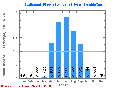
| Statistic | Jan | Feb | Mar | Apr | May | Jun | Jul | Aug | Sep | Oct | Nov | Dec | Annual |
|---|---|---|---|---|---|---|---|---|---|---|---|---|---|
| Mean | 0.00 | 0.02 | 0.53 | 0.83 | 0.90 | 0.70 | 0.50 | 0.14 | 0.01 | ||||
| Standard Deviation | 0.08 | 0.36 | 0.40 | 0.47 | 0.28 | 0.26 | 0.14 | 0.01 | |||||
| Min | 0.00 | 0.00 | 0.04 | 0.07 | 0.10 | 0.17 | 0.01 | 0.00 | 0.00 | ||||
| Max | 0.00 | 0.37 | 1.28 | 1.38 | 1.44 | 1.09 | 0.83 | 0.47 | 0.02 | ||||
| Coefficient of Variation | 3.35 | 0.69 | 0.48 | 0.52 | 0.39 | 0.51 | 0.94 | 1.27 |
 Return to R-Arctic Net Home Page